HCV 4 (ECOSYSTEM SERVICES)
The HCV definitions under the HCVRN (2013): Basic ecosystem services in critical situations, including protection of water catchments and control of erosion of vulnerable soils and slopes.
A) FOREST CRITICAL TO WATER CATCHMENTS
Findings on HCV Attribute
Water supply is a critical resource collected from the project area for the management and operation workers and visitors in USM and Sabah Foundation, and also adjacent communities for their daily livelihood consumption and other usage. There are a total of 5 water sources or intake from the project area catchments that continuously supply water to residents and guests in Infapro, Danum Valley Field Centre (DVFC), Taliwas, USM Management Office, Kawag Danum Rainforest Lodge (KDRL), and also communities that are residing at Kg. Silam and Kg. Bumiputera (Table 1 and Figure 1).
Table 1: Location of water Intake source for the USM-SFM Community and villages adjacent to Ulu Segama-Malua Sustainable Forest Management Project Area.
| Point No. | Site Name | Water Source | GPS Reading | |
| N | E | |||
| 1 | Borneo Rainforest Lodge (BRL) | Gravity | 05° 01’ 04.2” | 117° 44’ 40.4” |
| 2 | Infapro | River (Water Pump) | 04° 58’ 46.3” | 117° 51’ 08.6” |
| 3 | Danum Valley Conservation Area (DVCA) | Gravity | 04° 57’ 51.9” | 117° 48’ 03.1” |
| 4 | Taliwas | River (Water Pump) | 04° 59’ 39.0” | 118° 03’ 57.7” |
| 5 | PPD USM & Kawag Danum Rainforest Lodge (KDRL) | Gravity | 05° 02’ 49.9” | 117° 58’ 56.7” |
| 6 | Kg. Tampenau | Gravity 1 | 04° 59’ 39.4” | 118° 10’ 26.2” |
| Gravity 2 | 04° 58’ 44.6” | 118° 10’ 55.4” | ||
| 7 | Pekah | Dam | 05° 00’ 08.4” | 118° 10’ 20.0” |
| 8 | Kg. Silam & Kg. Bumiputera | Gravity | 04° 56’ 33.1” | 118° 10’ 07.1” |
Figure 1: The distribution of catchments of Ulu Segama-Malua Sustainable Forest Management Project Area, Sabah, Malaysia. 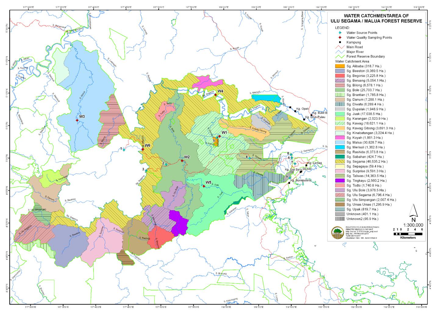
Justification of HCV Area |
The forested areas indicated as micro-catchments for all 5 intake points that are shaded in grey are categorized as HCV 4 (Figure 2) |
Potential Threats |
Forest simplification - As described above, these degraded areas could have a direct impact to the physical and terrestrial (biological) ecosystem throughout the forest landscape. Encroachment - Illegally harvesting of timber, clearing of vegetation for agricultural development and wildlife poaching are threats to the ecological well-being of the project area. Forest Fire - Degraded forest is more susceptible to forest fire during drought. If forest fire occurs, simplification of the forest could have a direct impact to the physical and terrestrial (biological) ecosystem throughout the forest landscape. |
Management Implications |
Similar as HCV 1 under the pretext of Protected Area, forest protection programme that address the threats of encroachment and forest fire should be implemented. All surveillance records should be placed in the main base office. Rehabilitation activities are required in areas that are critically needed for habitat restoration to avoid forest simplification and increase ecosystem structural and functional quality. |
Actions |
|
Figure 2: The forested areas shaded in grey are location of micro-catchments for the 5 water intake points are categorised as HCV 4, areas that are critical water catchments in Ulu Segama-Malua Sustainable Forest Management Project area, Sabah.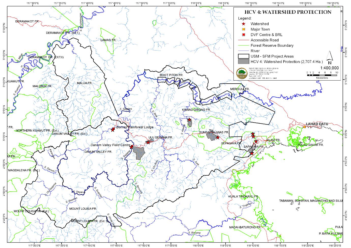
Measurable Effectiveness Indicators
The forested areas indicated as micro-catchments for all 5 intake points were managed and carried out obligatory actions to enforce the Forest Enactment 1968 and Forest Rule 1969 to ensure the security and protection of the reserve as describe in Forest Protection and Forest Fire Monitoring. Rehabilitation activities were also carried out at the critical area i.e. Ulu Segama Forest Reserve and VJR Sepagaya as describe in Rehabilitationthrough silviculture treatment activities.
B) FOREST CRITICAL TO EROSION CONTROL
Findings on HCV Attribute
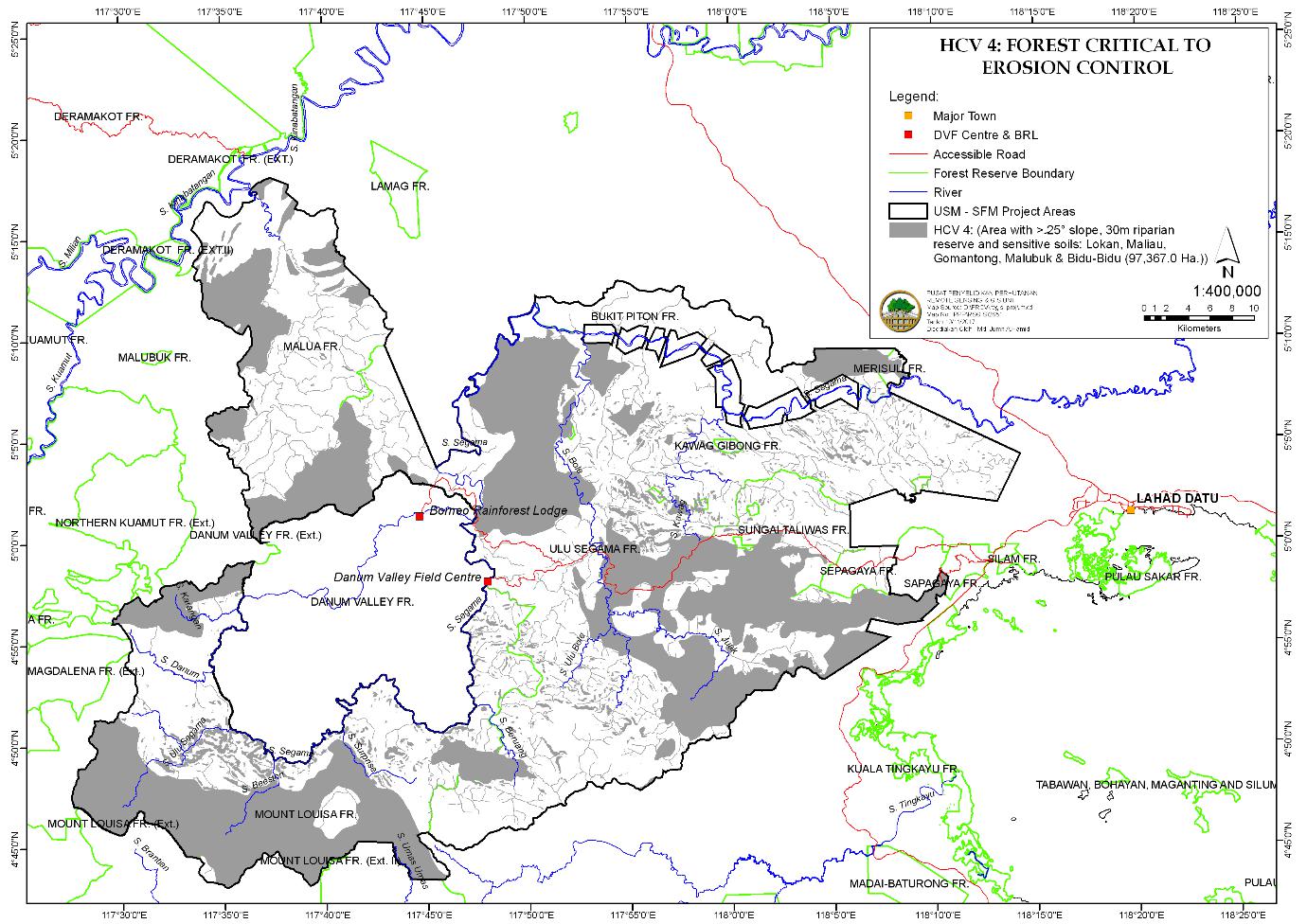
As mention in section 3.2.3, surface erosion becomes a particular concern in steep terrain, especially with slopes > 25°, and areas which have high sand but low in clay and silt content. These soils are sensitive soils that are prone to surface erosion during extreme wet season. In addition, riparian buffer appears to mitigate bank erosion and large sediment discharge, hence development that required removal of tree cover should be avoided.
Justification of HCV Area |
Forested areas overlie sensitive soils that are classified as Bidu Bidu, Melubok, Mentapok, Lokan, Maliau and Gomantong, with slopes >25° and 30 m riparian buffer strips should be categorised as HCV 4 for their importance in erosion controls (Figure 3) |
Potential Threats |
Forest simplification - As described above, these degraded areas could have a direct impact to the physical and terrestrial (biological) ecosystem throughout the forest landscape. Encroachment - Illegally harvesting of timber, clearing of vegetation for agricultural development and wildlife poaching are threats to the ecological well-being of the project area. Forest Fire - Degraded forest is more susceptible to forest fire during drought. If forest fire occurs, simplification of the forest could have a direct impact to the physical and terrestrial (biological) ecosystem throughout the forest landscape. |
Management Implications |
Similar as HCV 1 under the pretext of Protected Area, forest protection programme that address the threats of encroachment and forest fire should be implemented. All surveillance records should be placed in the main base office. Rehabilitation activities are required in areas that are critically needed for habitat restoration to avoid forest simplification and increase ecosystem structural and functional quality. |
Actions |
|
Figure 3: The location of areas with sensitive soils, slopes >25° and riparian reserve are categorised as HCV 4 in Ulu Segama-Malua Sustainable Forest Management Project area, Sabah.
Measurable Effectiveness Indicators
Forested areas overlie sensitive soils that are classified as Bidu Bidu, Melubok, Mentapok, Lokan, Maliau and Gomantong, with slopes >25° and 30 m riparian buffer strips were managed and carried out obligatory actions to enforce the Forest Enactment 1968 and Forest Rule 1969 to ensure the security and protection of the reserve as describe in Forest Protection and Forest Fire Monitoring. Rehabilitation activities were also carried out at the critical area i.e. Bukit Piton Forest Reserve, Ulu Segama Forest Reserve and VJR Sepagaya as describe in Rehabilitation.