WELCOME TO ULU SEGAMA-MALUA WEBSITE
The Ulu Segama-Malua Sustainable Forest Management Project (USM SFMP) was established on the 15th of March 2006 by the State Government of Sabah. The project is jointly managed by the Sabah Forestry Department (SFD) and Yayasan Sabah (YS), as the licensee. Consequently, to manage and administer the area, the Forestry District of Ulu Segama-Malua was established on the 1st April 2006. The project also involves direct participation from local and international Non-Government Organizations (NGOs) such as WWF Malaysia, Hutan, PACOS (Partnership of Community Organizations), SEARRP. The USM SFMP administered the largest complex of aggregated Totally Protected Areas that expand an area of 242,884 ha that is largely logged over of various regenerative conditions and pristine condition. Current management objective of the project area is to implement protection, conservation and management and utilization of all forest resources, while ensuring the ecological services and integrity of the area is maintained or enhanced. With the expansion from near coastal to montane zonation, USM secured various forest ecosystems and formed large contiguous forest landscape that connect to the larger natural landscape in the central part of Sabah. Not only USM act as natural buffer of ecosystem function for Danum Valley Forest Reserve forest, the last remaining pristine forest in the state, it's existence has also provide viable habitats for many threatened and endemic species for Sabah and Borneo.

Ulu Segama-Malua District Forestry Office in Kawag Forest Reserve
The Sabah Forestry Department is committed to the FSC Principles and Criteria in managing the SFM project. USM is the second model forest reserve for Sustainable Forest Management (SFM) managed by the Forestry Department of Sabah after the FSC-certified Deramakot Forest Reserve. The Ulu Segama-Malua SFM Project received its first Well Managed Forest Certification from Forest Stewardship Council (FSC) in June 2011 in Kota Kinabalu, and subsequently, was re-certified in June 2016 under the registration number SCS-FM/COC-00141N with an agreement of no commercial harvesting of timber until the 12th June 2021 and capitalizing the non-timber ecosystem services provided by the project area is encouraged.

In the first FMP (2008-2017), about 54,976 hectares of forest reserve was silvicultural treated mostly at southern and northern part of Ulu Segama Forest Reserve; and about 11,253 hectares was planted/rehabilitated mostly at Bukit Piton Forest Reserve.
Initially, the USM comprised of only six (6) Forest Reserves from three (3) forest reserve classes that is Class I – Protection Forest FR (Sapagaya FR), Class II – Production FR (Ulu Segama FR and Malua FR) and Class VI – Virgin Jungle Reserve (VJR Mersuli, VJR Kawag Gibong and VJR Sepagaya), with total area approximately 241, 098 ha. However, in 2012, a major part of Ulu Segama FR were reclassified and re-gazetted into a three portions of Class 1 FRs, namely Bukit Piton FR (11,612 ha), Sungai Taliwas FR (9,546 ha) and Mount Louisa FR (54,760 ha). The Malua FR was also reclassified as a Class I, Protection Forest Reserve in 2013. In 2014, the remaining Ulu Segama FR was reclasiffied and re-gazetted as a Class 1 Protection FR. In 2016, two (2) more Class 1 FR were also included as part of the USM SFM project, i.e. Extension Danum Valley FR Class 1 (92 ha) and Extension Mount Louisa FR Class 1 (1,786 ha). The re-classification of these forest reserves is necessary for the protection of the few remaining lowland mixed dipterocarp forest in Sabah and rare forest types - ultramafic forest, which are rich in biodiversity and endemism, and habitats to some of important terrestrial wildlife. The Ulu Segama-Malua (USM) Sustainable Forest Management (SFM) Project area is now comprise of eleven (11) Forest Reserves from two forest classes, that is, Class I – Protection FR and Class VI – Virgin Jungle Reserve, totalling area about 242,884 hectares. The updated forest reserves are shown as follows:
| FOREST RESERVE WITHIN ULU SEGAMA-MALUA SFM PROJECT | |||||||||
| No | FR Name | FR Class | FD Map | LS Plan | Coordinate | Area (Ha) | Gazetted No. | Year Gazetted | First Gazetted |
| Or Regazetted | |||||||||
| 1 | Sapagaya | I | 93/132A | 99194727 | 4̊ 57' N / 118̊ 10' E | 698.00 | 4/2009 | 2009 | 2009 |
| 2 | Ulu Segama(*) | I | 92 / 104D | 99194655 | 4̊ 57' N / 117̊ 55' E | 126,846.00 | 1/2012 | 2012 | 1961 |
| 3 | Mount Louisa | I | 91/100 | - | 4̊ 47' N / 117̊ 35' E | 54,760.00 | 1/2012 | 2012 | 1961 |
| 4 | Sungai Taliwas | I | 78/171 | - | 5̊ 00' N / 118̊ 02' E | 9,546.00 | 1/2012 | 2012 | 1961 |
| 5 | Extension Danum Valley | I | 76/248 | - | 5̊ 00' N / 117̊ 36' E | 92.00 | 7/2012 | 2012 | 1961 |
| 6 | Bukit Piton | I | 77/123 | - | 5̊ 09' N / 118̊ 00' E | 11,612.00 | 5/2012 | 2012 | 1961 |
| 7 | Malua | I | 76 / 1C | 99194548 | 5̊̊ 18' N / 117 ̊ 37' E | 33,969.00 | 1/2013 | 2013 | 1960 |
| 8 | Kawag Gibong | VI | 77 /67A | 99194614 | 5̊ 05' N / 118̊̊ 00' E | 707.00 | 4/1984 | 1984 | 1961 |
| 9 | Sepagaya | VI | 93 / 127 | 99194613 | 4̊ 59' N / 118̊ 07' E | 2,316.00 | 4/1984 | 1984 | 1961 |
| 10 | Merisuli | VI | 78 / 133A | 99194587 | 5̊ 09' N / 118̊ 08' E | 552.00 | 4/1984 | 1984 | 1961 |
| 11 | Extension Mount Louisa |
I | 91/101 | 1,786.00 | Sep 14 | 2014 | |||
| TOTAL | 242,884.00 | ||||||||
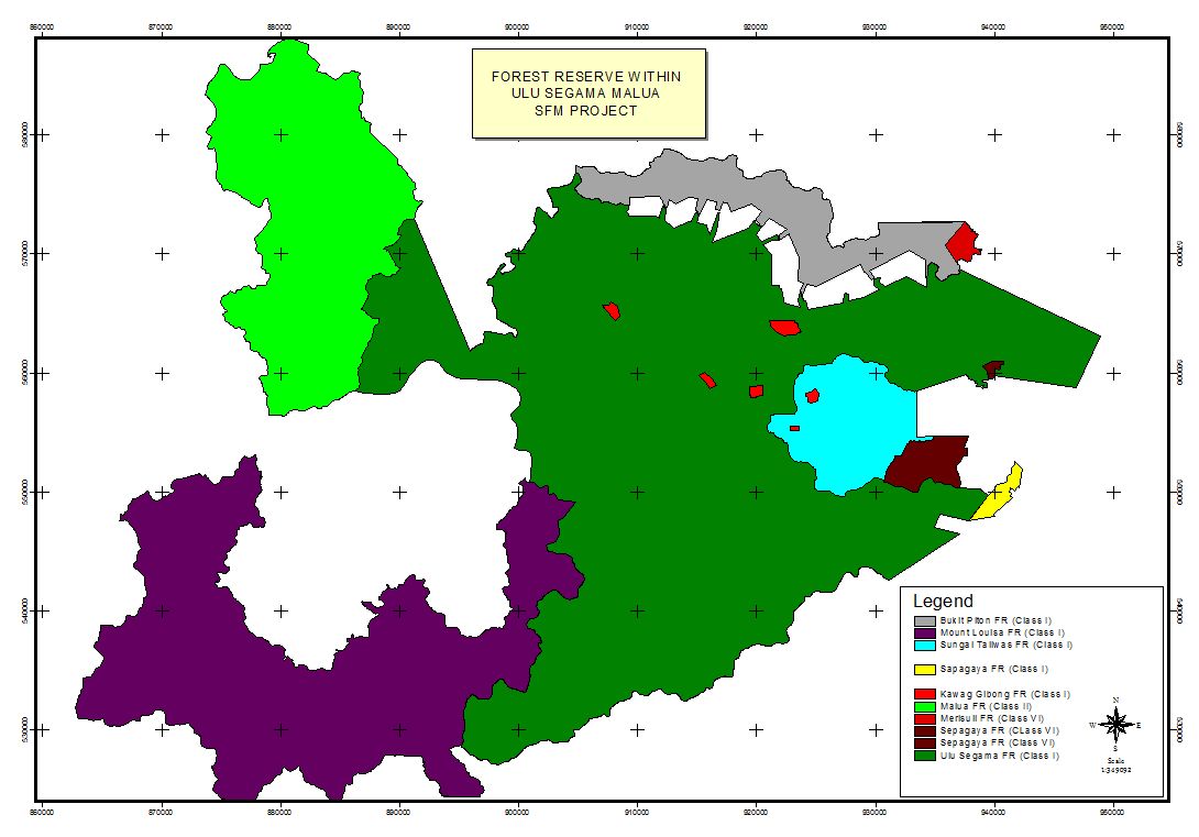
Map Showing forest reserves Class I within the Ulu Segama-Maloua Sustainable Forest Management Project
Website last updated on 29 Jul. 2021